4.1 General settings
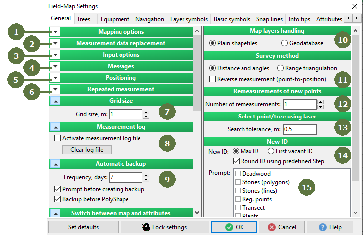
- Mapping options
Set of mapping options. Click the arrow button to roll/unroll this window.
- Measurement data replacement
Set of mapping options. Click the arrow button to roll/unroll this window.
- Input options
Set of input options. Click the arrow button to roll/unroll this window.
- Messages
Set of options regarding displaying messages. Click the arrow button to roll/unroll this window.
- Positioning
During the positioning procedure you can use one or two reference points for the calculation of your position. One point is usually enough, but two points may increase precision. Also you can use the Automatic positioning to new point of line function.
- Repeated measurement
Set of mapping options. Click the arrow button to roll/unroll this window.
- Grid size
Setting grid size. Click the arrow button to roll/unroll this window.
- Measurement log
Activating / deactivating of measurement log file. Click the arrow button to roll/unroll this window.
- Automatic backup
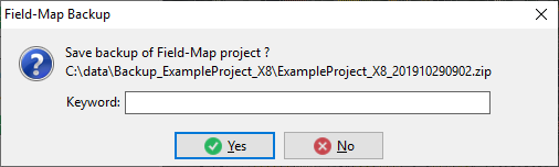
This option allows to set a frequency of automatic backup. You can (un)tag the check boxes to manual confirm procedure starting and before Polyshape automatic backup.
Example Backup window
- Map layers handling
Plain shapefiles: if selected, the GIS data of all plots are stored as ordinary files using ESRI shapefile format. There is a sub-directory MapLayers in the root directory of a project. For each plot there is a sub-directory with the same name as ID of the plot in this MapLayers directory. Storing all the GIS data as plain shapefiles is useful when you want to have all shapefiles available for other applications or software tools.
Store in geodatabase: if selected, just the GIS data of currently opened plot is stored using shapefiles (the same way as described for ‘Plain shapefiles’ option). The GIS data of all other plots is stored in the database instead of MapLayers directory. Field-Map stores geographic information using well-known binary format (WKB) that is supported by various database engines and GIS programs.
When the active plot is being changed, the GIS data of previously opened plot is stored back to the database and the shapefiles are replaced with the ones corresponding to newly selected plot. If FMDC is closed, all the GIS data is stored in the database and the MapLayers directory becomes empty. Storing GIS data in the database is useful especially for inventory projects where there is a large amount of plots and using this approach greatly improves the performance of data manipulation.
- Survey method
A mapping method using Distance and Angles orRange triangulation with a Reverse measurement possibility.
- Remeasurements of new points
During the measurement of a new point it is possible to use multiple measurement to obtain a higher precision. This can be used for the measurement of any point or points of the line.
- Select point/tree using laser
Field-Map function “Select using laser” uses this number as a threshold distance for tree or point searching. You might lower the number in dense forest to be sure that the tree is the one you are searching for, and you might increase it in low dense forest to be able to find the point (tree) faster.
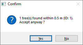
If you measured a tree position close to any tree, you can get this confirm window. If you click on Yes button - then the measured tree will be stay on the map, if you click on No button - then the measured tree will be deleted.
- New ID
If "Max ID" is selected a new entity will get ID one unit higher than the highest existing ID. If "First vacant ID" is active the new entity will get the lowest vacant ID, which is not used by any other entity of the same type. If active "Round new ID using predefined step" function, Field-Map will calculate a new ID according to this formula :
NewID=((LastID div Step)*Step) +Step.
E.g., Last ID=21, Step=10, NewID=30.
- Prompt for new ID: map and data layers
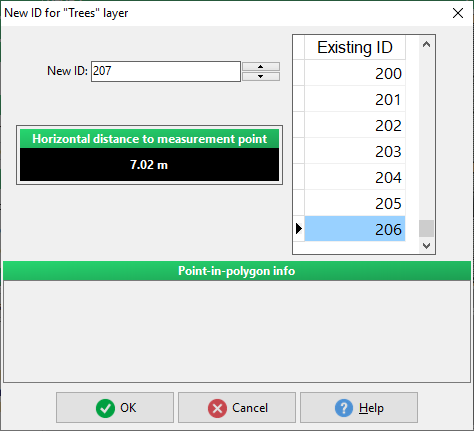
If not active, Field-Map will automatically define the ID of new entity or record based on “New ID” option (see point 14). You can decide for “Prompt window” for each map and data layer.
A window with confirm a new ID for a tree
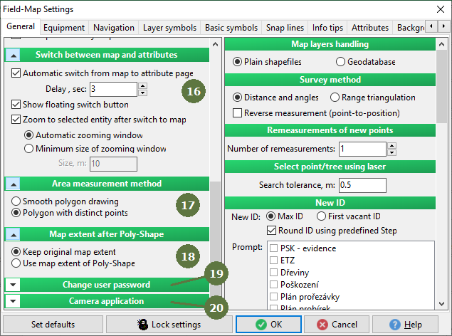
- Switch between map and attributes
If active, Field-Map will automatically switch from map to attribute table after adding a new entity into a map. Also you can specify delay of this switch and tag whether to show floating switch button. reference.
- Area measurement method
When measuring and calculating area of polygon its borders can be smoothed to make its shape more realistic. However its area and circumference can be slightly different compared the approach based on sharp borders. reference.
- Map extent after Poly-Shape
Specifies the extent of map after using Poly-Shape function. reference.
- Change user password
Available only when user accounts allowed in Project Manager, reference
- Camera application
Specifies application to be used while taking picture within attribute type Photo shot. reference